"Exploration is the engine that drives innovation. Innovation drives economic growth. So let's all go exploring.“ - Edith Widder

Services


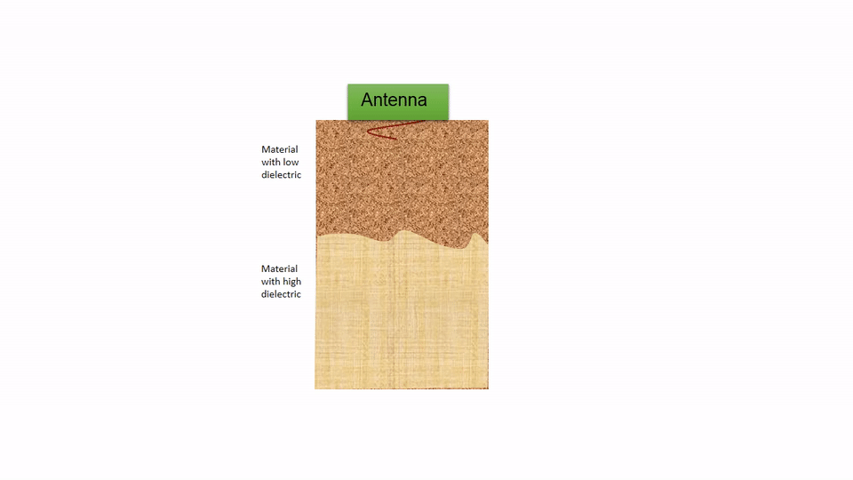
    Ground penetrating radar (GPR) is a tool capable of imaging subsurface non-destructively.

 
    It is based on electromagnetic technique and provides high resolution subsurface profiles which help in mapping the underground features effectively.
 
    The depth of penetration for a GPR ranges from a few centimeters to larger depth of around 15-20 meters.

Utility Mapping

    Map the underground utilities before trenching to prevent the damage of the pre-existing underground assets. An extensive 3-D sub-surface profile of the region can be generated.

    • Mapping both metallic and non-metallic buried utilities.

    • Water and gas pipeline

    • Sewer line & cables

    • Storage tanks, etc.

Transportation Infrastructure Inspection

    While GPR is not traditionally used to examine the structural robustness of bridges and roads, they are in fact a fantastic way to examine weak links and flaws in these structures, potentially saving not only money but probably many lives in the process as well.
    Our main services include

     
    • Railway Ballast Inspection 
     
    • Accessing the pavement condition

Concrete Structure Inspection

    Construction professionals along with cutting and coring experts need extensive sub-structure profiles prior to cutting or drilling. Geocarte’s GPR consultancy services help you prepare in-depth concrete structure profiles for flawless operation

     
    • Locating voids in Concrete Structures
     
    • Measurement of Slab thickness

Archaeological Investigation

    Prior to excavation of a site, an elaborate map of the sub-structure is to be drawn. GPR allows you to non- invasively determine sub-surface artifacts, their location and composition to ensure none of the items are damaged while digging.

     
    • Locate Archaeological features
     
    • Map potential site for excavation

Other services

    • Ground water table mapping


    • Tunnel & Land mine detection


    • Mineral Exploration


    • Railway Ballast Investigation


    • Underground pipe leakgae detection